 Tools
Tools Tools
ToolsHarrison, Flo, Burgoine, Thomas, Corder, Kirsten, van Sluijs, Esther M F and Jones, Andy (2014) How well do modelled routes to school record the environments children are exposed to?:A cross-sectional comparison of GIS modelled and GPS measured routes to school. International Journal of Health Geographics, 13. ISSN 1476-072X
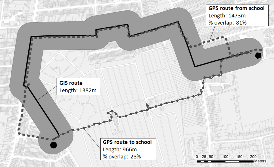
![[thumbnail of figure1]](https://ueaeprints.uea.ac.uk/48941/1/figure1.bmp) 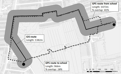 Preview |
Image (BMP) (figure1)
- Accepted Version
Available under License Creative Commons Attribution. Download (1MB) | Preview |
![[thumbnail of GISvsGPS_routes_to_School_PAPER_FINAL_revJan14_v2_21-01-14]](https://ueaeprints.uea.ac.uk/style/images/fileicons/application_msword.png) |
Microsoft Word (GISvsGPS_routes_to_School_PAPER_FINAL_revJan14_v2_21-01-14)
- Accepted Version
Available under License Creative Commons Attribution. Download (108kB) |
Preview |
PDF (Published_Version)
- Published Version
Available under License Creative Commons Attribution. Download (537kB) | Preview |
Abstract
Background The school journey may make an important contribution to children’s physical activity and provide exposure to food and physical activity environments. Typically, Geographic Information Systems (GIS) have been used to model assumed routes to school in studies, but these may differ from those actually chosen. We aimed to identify the characteristics of children and their environments that make the modelled route more or less representative of that actually taken. We compared modelled GIS routes and actual Global Positioning Systems (GPS) measured routes in a free-living sample of children using varying travel modes. Methods Participants were 175 13-14 yr old children taking part in the Sport, Physical activity and Eating behaviour: Environmental Determinants in Young people (SPEEDY) study who wore GPS units for up to 7 days. Actual routes to/from school were extracted from GPS data, and shortest routes between home and school along a road network were modelled in a GIS. Differences between them were assessed according to length, percentage overlap, and food outlet exposure using multilevel regression models. Results GIS routes underestimated route length by 21.0% overall, ranging from 6.1% among walkers to 23.2% for bus users. Among pedestrians food outlet exposure was overestimated by GIS routes by 25.4%. Certain characteristics of children and their neighbourhoods that improved the concordance between GIS and GPS route length and overlap were identified. Living in a village raised the odds of increased differences in length (odds ratio (OR) 3.36 (1.32-8.58)), while attending a more urban school raised the odds of increased percentage overlap (OR 3.98 (1.49-10.63)). However none were found for food outlet exposure. Journeys home from school increased the difference between GIS and GPS routes in terms of food outlet exposure, and this measure showed considerable within-person variation. Conclusions GIS modelled routes between home and school were not truly representative of accurate GPS measured exposure to obesogenic environments, particularly for pedestrians. While route length may be fairly well described, especially for urban populations, those living close to school, and those travelling by foot, the additional expense of acquiring GPS data seems important when assessing exposure to route environments.
| Item Type: | Article |
|---|---|
| Additional Information: | © 2014 Harrison et al.; licensee BioMed Central Ltd. This is an Open Access article distributed under the terms of the Creative Commons Attribution License (http://creativecommons.org/licenses/by/2.0), which permits unrestricted use, distribution, and reproduction in any medium, provided the original work is properly cited. The Creative Commons Public Domain Dedication waiver (http://creativecommons.org/publicdomain/zero/1.0/) applies to the data made available in this article, unless otherwise stated. |
| Faculty \ School: | Faculty of Medicine and Health Sciences > Norwich Medical School |
| UEA Research Groups: | Faculty of Medicine and Health Sciences > Research Groups > Epidemiology and Public Health Faculty of Medicine and Health Sciences > Research Centres > Business and Local Government Data Research Centre (former - to 2023) Faculty of Medicine and Health Sciences > Research Groups > Health Promotion Faculty of Medicine and Health Sciences > Research Groups > Public Health and Health Services Research (former - to 2023) |
| Depositing User: | Pure Connector |
| Date Deposited: | 07 Jul 2014 13:38 |
| Last Modified: | 04 Feb 2026 17:43 |
| URI: | https://ueaeprints.uea.ac.uk/id/eprint/48941 |
| DOI: | 10.1186/1476-072X-13-5 |
Downloads
Downloads per month over past year
Actions (login required)
 |
View Item |